You hear about microseismic location error everywhere and how they affect the usage and interpretation of these data streams. Have you ever wondered how this error is calculated?
The location of a microseismic event is determined through evaluation of how well observations like picks and hodograms are consistent with a series of test locations. Through intelligent choices of these test locations, the hope is that the location algorithm will determine the location that best fits these observations.
The consistency of the location with the measured data is evaluated through a misfit function, a simple example of such a function would be the average difference of the measured and modelled traveltimes (the average traveltime residual) from a given test location to the receivers.
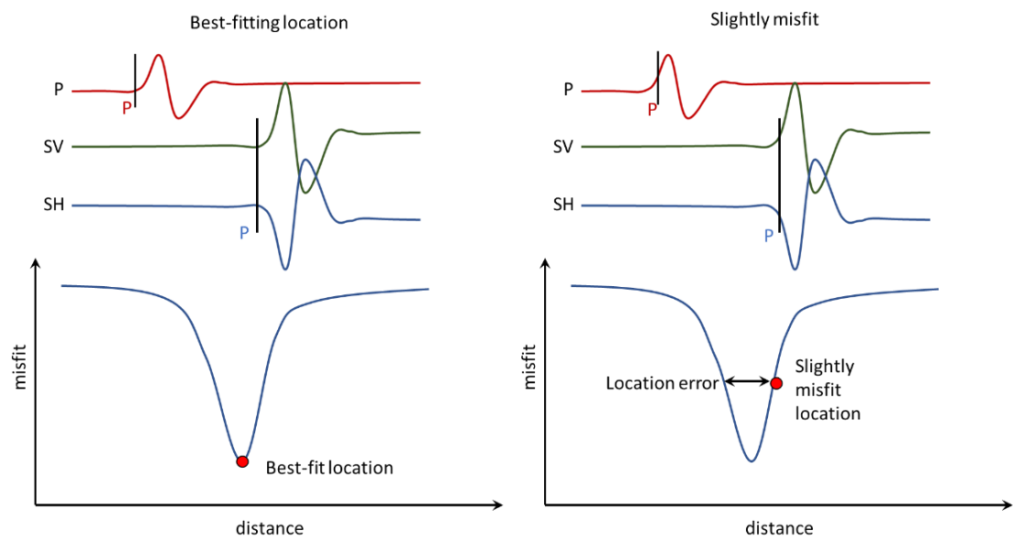
A schematic diagram for how location error and misfit relate to one another is shown above. In the example, the picks corresponding to the best fitting location are plotted on the waveform on the top left. The misfit function corresponding to that location is illustrated below that. When the location is shifted, the picks slightly misfit to the onsets of the waveforms. When the picks just exceed what can be considered as adequate, then a measure of location error can be calculated. In the figure above, if it is asserted that the shift in the location is just starting to significantly affect the fit of the picks to the waveform, then the distance shifted is an estimate of location error.
Above 👆 is the “Surface locator” simulation of the metaKinetic platform. This simulation facilitates understanding of effective parameters on resolving better location with higher accuracy. Want to have access to this simulation and investigate these effective parameters on your own? Contact us!